

Scenic swamps, cypress brakes and abundant wildlife are a treasure trove at the fingertips of outdoor enthusiasts
By DR. TODD DAVIS and ROBIN WHITFIELD
Photography by ROBIN WHITFIELD, HART HENSON and LARRY PACE
The Mississippi Delta is best known as the catalyst for rock ‘n’ roll by way of Delta blues music. It is the home of Conway Twitty, Sam Cooke, and B. B. King, as well as the burial site for the legendary Robert Johnson.
The National Park Service refers to the Mississippi Delta as “the cradle of American culture.”
What people may not know is the Delta was a vast jungle of swamps and canebrakes. During the twentieth century, commercial agricultural significantly impacted the region through deforestation for its rich sediment and optimum growing conditions. Annual flooding was controlled by the construction of a complex levee system yielding civilizations to sprout. The area is an agricultural portrait of success with small jewels of nature offering public access scattered within the Delta’s landscape.

The Mississippi Delta is a large, flat, fertile region in west-central Mississippi formed by the Mississippi and Yazoo Rivers. The Mississippi Delta, although a floodplain of the Mississippi River, is the actual delta of the Yazoo River. Some seventy miles wide at the greatest point and stretching nearly two hundred miles south of Memphis to Vicksburg, the Delta is 4.4 million acres of sedimentary flatland.
Indigenous people settled, inhabited, and thrived within the Mississippi Delta region from 700 A.D. well into the sixteenth century. They farmed, hunted, and traded using the Mississippi River as transportation. Canoes dug out of bald cypress trees were used to transport goods and explore the Delta.
The first European to explore the Delta and cross the Mississippi River was Spain’s Hernando de Soto during his quest for gold and silver in 1541. Sadly, his expedition introduced not only contagious diseases among the Native Americans that would nearly wipe out the population but also a combative relationship triggering numerous battles killing many. The European-influenced Delta of today emerged after the signing of Dancing Rabbit Creek in 1830 forcing native peoples west.
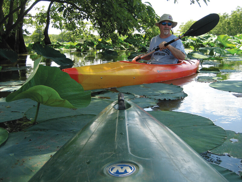
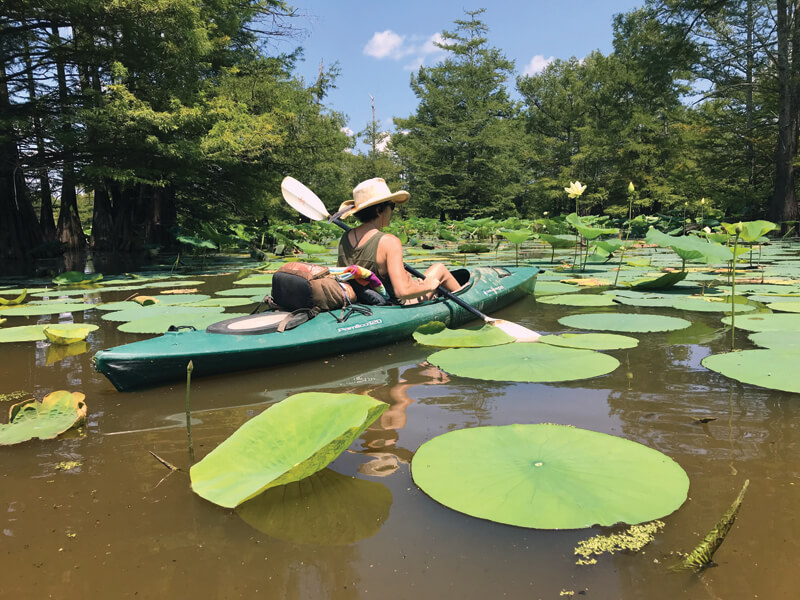
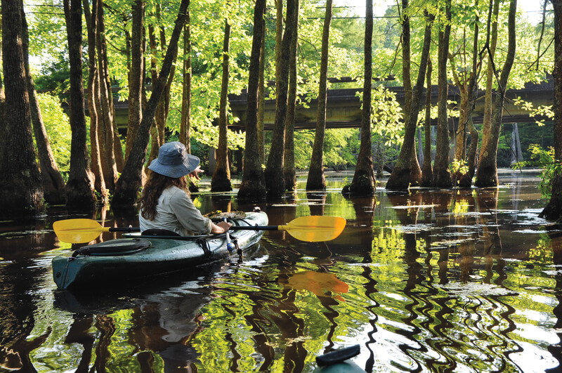
Although most of the Delta is comprised of expansive croplands, there are pockets of unique outdoor opportunities. From swamps, small rivers, and hardwood wetlands, the region provides glimpses of the original landscape prior to cropland expansion. Distinctive conifer and broadleaf trees blanket region. The bald cypress, cousin to the famous redwoods of California, is the most iconic conifer of the area while the water tupelo is its broadleaf counterpart. Together they make up the cypress tupelo swamps loved by songbirds, waterfowl, and a great diversity of aquatic plants and animals.
The forest understory provides habitat for native wildlife but also serves migrating visitors. Yearlong residents roam the wooded areas including opossum, bobcat, raccoon, black bear, and the state mammal, the white-tailed deer. In the treetops, habitat is provided for the southern flying squirrel, bald eagle, red-shouldered hawk, and red bats. In the wetlands, the American alligator, river otter, and beaver thrive alongside a variety of snake, turtle, and freshwater fish and mussel species. Birds, like the downy woodpecker, barred owl, pileated woodpecker, and northern cardinal, are permanent residents.
The Mississippi Flyway funnels millions of non-resident birds through the Delta. This has created a hot spot for thousands of birding enthusiasts to track, observe, and identify unique species found in one location. Wildlife researchers estimate 320-350 species, including 40 percent of all waterfowl, utilize this flyway to access warmer climates. Colorful neotropical migratory birds like warblers, cuckoos, and tanagers come from Central America each spring to breed in the bottomland forests. The prothonotary warbler is a unique and welcomed visitor from Central and South America. Breeding in hardwood swamps, these small, golden warblers nest in the cavities of old cypress trees, sometimes using old woodpecker holes.
Sadly, deforestation and habitat depletion has significantly diminished migratory and resident birdlife. Some estimates suggest only 2 percent of natural Delta habitat exists for wildlife, making these spaces important to preserve and better understand their impact.
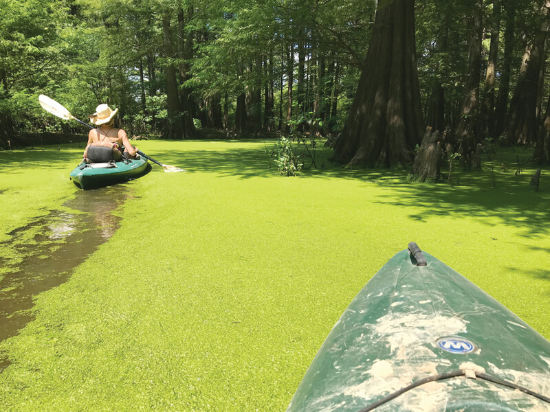
With several public access points to lake or swamp waters, the Delta provides a portal to exploration connecting people with nature. The areas discussed below are mostly covered in water year round, allowing a canoe or kayak to serve as the perfect vehicle. Kayaks and canoes are quiet, easy to transport, require little skill to maneuver, and are environmentally friendly.
It should be noted, the four areas discussed here are approved paddling destinations on city, state, or federal lands. Much of the Mississippi Delta is comprised of private land and has strict laws forbidding trespassing, even paddling. Be sure you contact your local agency governing land and property prior to paddling any bodies of water.
Mathews Brake National Wildlife Refuge
Mathews Brake is a National Wildlife Refuge operated by the United States Fish and Wildlife Service. Established in 1980, the nearly 2,500 acres are comprised of shallow bottom brush and cypress swamp with a 1,800-acre oxbow lake. The lake provides habitat for thirty thousand waterfowl in the winter months. Several species of wading birds such as egrets, herons, and the rare visitation of wood storks and roseate spoonbills frequent the refuge. Wildlife managers estimate that over 225 species of migratory birds visit Mathews Brake, with over seventy species using the region for breeding.
Look For: wood ducks, snowy egrets, great egret, prothonotary warblers, black-bellied whistling ducks, roseate spoonbills, and yellow-crowned night herons. American alligators and American lotus are abundant.
Directions: Refuge is nine miles south of Greenwood and five miles west of Sidon, Mississippi, between Highway 49E and Highway 7. Paved and graveled county roads provide access. From Highway 49S use School Street east to County Road 511 east (aka Phillipston Road). At the junction, take County Road 249/250 south to Mathews Brake Road (County Road 249) south.
Access: A boat access ramp will be on the right 1.5 miles from County Road 250/249 split.
Sky Lake Wildlife Management Area
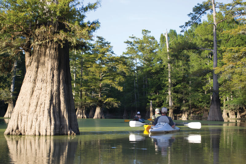
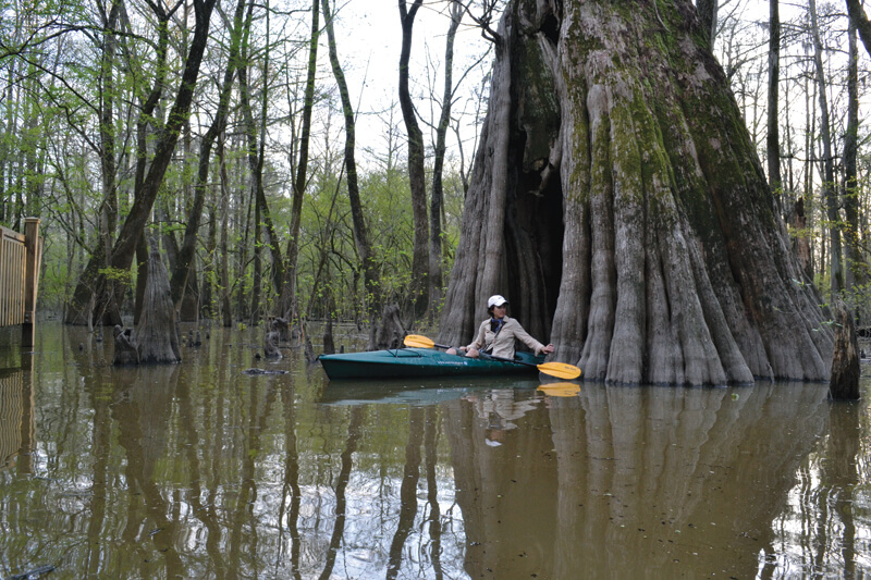
Sky Lake WMA, considered a Mississippi natural wonder, is a 3,500-acre lake owned by the Mississippi Department of Wildlife, Fisheries, and Parks. A partnership between the Sky Lake Wildlife Management Area (WMA) and the U.S. Army Corps of Engineers assists in supporting this important historical region. Dr. Stahle, the director of the Tree Ring Laboratory at the University of Arkansas and a leading American dendrochronologist stated, “Based on our field inspections and core samplings, I can state with certainty that Sky Lake contains some of the largest and oldest bald cypress trees that remain on earth, and they have international scientific significance.” A functioning backwater ecosystem, Sky Lake offers outdoor recreationists an amazing 2.6-mile paddling trail exploring the heart of what experts believe are ancient 1000-yr-old-plus bald cypress trees. The trail is divided into four segments and uses colored signs to designate each section. Along this trail, one can paddle beside the former record-holding bald cypress tree. Now the second-largest tree in Mississippi and the largest in Sky Lake, this tree measures forty-six feet nine inches in circumference, nearly fifteen feet in diameter, and just over seventy feet high. Like other lakes and swamps in the Delta, Sky Lake is an important habitat for wildlife including snakes, frogs, turtles, and American alligators, along with shorebirds and neotropical songbirds.
Look For: Pileated woodpecker, prothonotary warbler, roseate spoonbill, and wood ducks as well as the non-poisonous broad-banded water snake, one of many snake species.
Directions: The boardwalk is located at the Sky Lake Wildlife Management Area, which is north of Belzoni. At the intersection of US Highway 49W and Highways 12 and 7 (at Belzoni), turn east onto Highway 7 (1st Street). At the first traffic light, the intersection of Highway 7 (also named Martin Luther King Drive) and Hayden Street, turn left. When the road forks at Old Highway 49 and Highway 7, bear right on Highway 7 and continue for approximately 4.9 miles to the intersection of Four Mile Road. Turn left and travel approximately 0.9 miles to the intersection of Simmons Road. Turn left on Simmons Road and travel approximately 0.8 miles, staying on the blacktop, to the entrance of the facility, which will be on the right.
Access: Public parking, a picnic pavilion, and public restrooms are available. In addition, a 1,700-foot-long elevated boardwalk allows visitors to access the forest. A kayak ramp is adjacent to boardwalk entrance.
Lee Tartt Nature Preserve
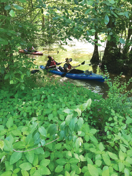
Lee Tartt Nature Preserve, although not technically in the Mississippi Delta, is a must-paddle area in the flood plain of the Yalobusha River. Owned by the City of Grenada and managed by Friends of Chakchiuma Swamp, this amazing area is located just a few miles east of the Delta. Lee Tartt Nature Preserve is a three-hundred-acre wetland parcel along the Yalobusha River. Just 0.25-miles from the city center, the urban preserve is comprised of oxbow lakes and a bottomland forest, providing a rich habitat for birdlife, aquatic animals, and snakes. The area prides itself on providing opportunities between users and nature by preserving the cultural and natural landscape through responsible recreation and creative interaction.
Look For: Prothonotary warbler, barred owl, red-shouldered hawk, river otter, great blue heron, white tail deer, and raccoon.
Directions: 320 South Main Street, Grenada, Mississippi 38901. From the Grenada City Center, take Main Street north .25 miles. The preserve is located adjacent to the Yalobusha River. Find more info at friends-of-cs.org
Access: A short boardwalk with an observation patio is present. A small clearing is available to launch canoes and kayaks just to the right of the boardwalk entrance.
Tallahatchie National Wildlife Refuge
Tallahatchie National Wildlife Refuge is managed by the United States Fish and Wildlife Service. This 4,200-acre refuge, established in 1990, affords two small and narrow oxbow lakes. Tippo Bayou and Long Branch, both with thriving hardwood bottomland swamps, support numerous species including wintering waterfowl and wading birds. Beautiful bald cypress and water tupelo dominate the forest and wetland area.
Look For: Wood ducks, hooded mergansers, herons, egrets, fresh water mussels, spotted gar, and swamp crayfish.
Directions: Tallahatchie National Wildlife Refuge is located on the north and south sides of Highway 8, nine miles west of Holcomb. Please note that gated roads are open from mid-September through May 1.
Access: A unique feature to this refuge is a two-tier observation deck, a three-story observation tower, and boat ramp accessible from Highway 8. There is no boat launch fee and parking is available.
Best time to visit these areas
Migratory bird season (late fall to early spring) is the most ideal time to visit with moderate to low temperatures and optimal water level. Early spring can have extreme high water conditions that may inhibit paddling. Summer can be extremely hot, and water levels can fluctuate. Paddling is best in the morning and evening when wildlife is most active and conditions are cooler.
Know before you go
Ensure you have appropriate paddling gear and equipment, including a personal floatation device (PFD), plenty of drinking water, insect repellent, and sunscreen. Some of the areas listed do not have consistent cellular phone connectivity, so inform a friend or relative of your whereabouts and your float plan. Poison ivy and thorny vegetation are present along the sides of bodies of water, so beware. Watch your step; venomous snakes and other wildlife can be found on hiking trails and roads. It is illegal to harass or injure any wildlife (including snakes) while on the refuge.